Sunday, November 27, 2016

The Future of the Dead Sea

Background of the Dead Sea
The Dead Sea is a beautiful phenomenon that is located between Israel and Jordan. It is a pull-apart basin that was created by the Dead Sea Transform (DST). The Jordan River is one of its main source of water, and the Dead Sea has no outlet. The Dead Sea is about 422 meters below sea level, which makes it one of the lowest points on Earth. It is relatively a dry arid region because it is located on the Leeward side of the Judean Mountains causing it to be affected by the rain shadow effect. The Dead Sea is also one of the most hypersaline lakes on Earth, so there is no life present in this lake.

Current Conditions of the Dead Sea
The Dead Sea is constantly sinking due to the DST movement because it is estimated to be moving 5-7 mm per year (1). As well, the Dead Sea has dried up quite a bit over the past decades, especially in the southern parts. The Dead Sea's surface water is "dropping more than a meter each year" (2). As well, humans have a large impact on the decreasing water levels through the increased use of evaporation basins and irrigation. They have also contributed to global warming, which also has a major effect on the Dead Sea.
This picture shows how the Dead Sea has changed over the years and where the evaporation basins are located
Picture from http://www.bbc.com/news/world-middle-east-36477284

This graphic shows how much and where the Dead Sea has lost its water over the time period of 1960-2007.
Source: https://en.wikipedia.org/wiki/Dead_Sea


Evidence of the Dead Sea's decreasing water levels
Picture from: http://e360.yale.edu/feature/the_dead_sea_is_dying_can__a_controversial_plan_save_it/2551/

The Dead Sea 10,000 Years from Now
In 10,000 years from now, I think the Dead Sea will be fully dried up with no water left in the basin. This physical change can be attributed to climate change as the planet is warming. Global warming can cause areas all around to planet to have an increase in warmer temperatures. Thus, the Dead Sea already has a warm, dry climate and global warming can increase the intensity of warmer temperatures. This increase of warmer temperatures will increase the rate of evaporation from the Dead Sea, which will cause it to dry up faster. In other words, the rate of evaporation in the Dead Sea will be higher than the amount of water coming into the basin. Overall, all that would be left in the Dead Sea is salt deposits.

The Dead Sea 1,000,000 and 10,000,000 Years from Now
1,000,000 and 10,000,000 years from now, the Dead Sea will contain nothing and it would be left as a giant sinkhole. All of the salt deposits probably would have been collected by humans for their personal use. As well, since there would be no water left in the lake and the DST continues to move, it will cause the Dead Sea to sink at a faster rate. Therefore, the Dead Sea will be nothing but a giant sinkhole in between Israel and Jordan.

There have already been sinkholes around the Dead Sea
Picture from http://www.bbc.com/news/world-middle-east-36477284
Conclusion
Overall the Dead Sea is shrinking and sinking at a constant rate every year. Even today, it has reached lower levels. The future of the Dead Sea is in the palms of our hands in terms of our contributions to climate change, the use of evaporation basins, and increase use of irrigation.


Sources:
1. Extreme Science. (n.d). Lowest Elevation: Dead Sea. Retrieved from http://www.extremescience.com/dead-sea.htm

2. Connolly, K. (2016). Dead sea drying: A new low point for Earth. Retrieved fromhttp://www.bbc.com/news/world-middle-east-36477284

Friday, November 4, 2016

Plate Tetonic and Faulting of the Dead Sea

The formation of the Dead Sea is caused by a plate interaction between the Arabian plate and the African-Sinai plate. The interaction between those two plates is also known as the Dead Sea Transform (DST). The DST is a 1000 km continental transform that extends from the Red Sea to the Taurus Zagros collision zone. The DST is a left-lateral strike-slip fault, therefore the Arabian plate and the African-Sinai plate interact through a side-by-side movement. In some areas of the DST, the two plates also pull apart from each other (extension fault), which is a diverge-plate interaction.  
  
The African plate is located on the west side of the Dead Sea, while the Arabian plate is located on the east side.This picture gives the overall indication of where the plates transform and diverge.
Picture from: https://www.see.leeds.ac.uk/structure/leb/tectonics/regional/regional.htm
This image gives a great detailed description of the plate interactions between the Arabian Plate and African Plate such as its location and the direction of its movement. It also shows the location of the Dead Sea along the Dead Sea Transform.
Picture from https://thenaturalhistorian.com/2014/09/06/origins-of-the-dead-sea-part-iii-the-levant-a-land-literally-torn-apart/  
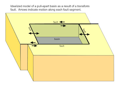
The Dead Sea is located in the southern part of the DST, and the two fault systems (strike-slip and extension) overlap with each other in this area. This overlap creates pull-apart basins, which occurs when "two overlapping faults or a fault bend create an area of crustal extension undergoing tension that causes the basin to sink down” (7). Thus, the Dead Sea is none other than a pull-apart basin. The extension fault system is a large component involved in the creation of the Dead Sea. In other words, the two plates pull apart from each other creating a down faulted valley (graben), which is now the Dead Sea. 

The extension fault also contributes to the downwards sinking motion of the Dead Sea. As the Arabian plate and the African-Sinai plate diverge, the earth’s crust stretches thin. Consequently, the area where the earth’s crust is thinning starts to sink downwards. Hence, the Dead Sea is located right where the earth’s crust stretches thin, which causes it to sink. The continuous fault movements of the DST are moving 5-7 mm per year, and this movement contributes to the continuous sinking of the Dead Sea. In fact, "scientists estimate that the Dead Sea is sinking by 13 inches per year" (4).   
This picture shows how a pull-apart basin is formed from a transform fault. The transform fault is shown on the top and the bottom of the diagram, and on the side it shows the extension fault.
Picture from: http://woodshole.er.usgs.gov/project-pages/dead_sea/tectonic.html

This picture shows the tectonic movements on the left and on the right you can see a focus on the Dead Sea topography. In the right image you can see how the Dead Sea is a valley, as that area sinks downwards between two topographic barriers.
Picture from: http://woodshole.er.usgs.gov/project-pages/dead_sea/tectonic.html


Sources:
  1. Allen, C. (2016). Lecture 11: Plate Tetonics. Personal Collection of C. Allen, University of Colorado Denver, Denver, CO.
  2. Allen, C. (2016). Lecture 14: Faults and Folds Part A & B. Personal Collection of C. Allen, University of Colorado Denver, Denver, CO.
  3. Ben­Avraham, Z., & Katsman, R. (2015). The formation of graben morphology in the dead sea fault, and its implications: GRABEN MORPHOLOGY IN THE DEAD SEA FAULT. Geophysical Research Letters, 42(17), 6989­ 6996. doi:10.1002/2015GL065111
  4. Extreme Science. (n.d). Lowest Elevation: Dead Sea. Retrieved from http://www.extremescience.com/dead-sea.htm
  5. Klinger, Y., Avouac, J. P., Dorbath, L., Karaki, N. A., & Tisnerat, N. (2000). Seismic behaviour of the dead sea fault along araba valley, jordan. Geophysical Journal International, 142(3), 769-782. doi:10.1046/j.1365-246x.2000.00166.x
  6. Natural Historian. (2014). Origins of the Dead Sea Part III: The Levant – A Land Literally Torn Apart. Retrieved from https://thenaturalhistorian.com/2014/09/06/origins-of-the-dead-sea-part-iii-the-levant-a-land-literally-torn-apart/
  7. Wikipedia. (n.d.). Pull-apart basin. Retrieved from https://en.wikipedia.org/wiki/Pull-apart_basin


Wednesday, October 5, 2016

Rain Shadow Effect, Temperature, & Climate

The Dead Sea is located in between Israel and Jordan in the Jordan Rift Valley. The Dead Sea is one of the lowest points on Earth, which is 422 meters below sea level.

Location of the Dead Sea on the Map
From: Google Maps
Location of the Dead Sea in the Jordan Rift Valley
Picture from: http://buypanicdisorderpill.com/files2/jordan-rift-valley-map.html

The Dead Sea is a dry area which is caused by the rain shadow effect. A rain shadow occurs in areas located on the leeward side of a topographical barrier. Therefore, the Dead Sea is a rain shadow area located on the leeward side of the Judaean Hills. The clouds that move from the Judaean Hills towards the Dead Sea are formed over the Mediterranean Sea. As the clouds move up the Judaean Hills, the temperature and pressure decreases and rain is produced. Then as the clouds move down into the Dead Sea, the temperature and pressure increases with no rain produced. On average the Dead Sea gets less than 50 mm of rain each year. The minimal rainfall causes the Dead Sea area to be dry and to have little to no green areas surrounding it.

There are more green areas on the left of the Judaean Hills, but as you move towards the Dead Sea there is little to no green areas. This is caused by the rain shadow effect. 
From: http://www.biblewalks.com/sites/desertWater.html
This a video of the clouds dissipating over the Dead Sea


Due to the rain shadow effect and its low elevation, the temperatures of the Dead Sea are dry and warm year round. The Dead Sea is a part of the subtropical climate zone, which is not quite tropical or cool. The highest temperatures are in the summer months (June, July, and August), which can range from 90°F to 100°F. The lowest temperatures occur during the winter months (December, January, and February), which range from about 68°F to 73°F. The differences in temperature in these two seasons can be attributed to the Earth's temperature patterns in January and July. In January the thermal equator moves southward, and in July it moves northward. As well, the dry climate and minimal rainfall both contribute to the low relative humidity of the Dead Sea.


The average maximum and minimum temperature, and the average relative humidity in each month.
From: http://www.deadseatourist.com/climate.htm


Sources:
  • Allen, C. (2016). Lecture 6: Earth's Temperature, Concepts, ad Patterns. Personal Collection of C. Allen, University of Colorado Denver, Denver, CO.
  • Allen, C. (2016). Lecture 9: Weather, Adiabatic Processes, and Storms. Personal Collection of C. Allen, University of Colorado Denver, Denver, CO.
  • Climate | DeadSea.com. (2016). Retrieved from http://www.deadsea.com/articles-tips/interesting-facts/climate/ 
  • Hitton, S. (n.d.). Climate in the Dead Sea. Retrieved from http://traveltips.usatoday.com/climate-dead-sea-16260.html


Wednesday, August 24, 2016

Introduction

Hello everyone and welcome to my blog! My name is Sabrina Lor and I was born and raised here in Colorado. My hobbies consist of playing sports and baking. I also enjoy being outdoors and spending time with my family. I'm a third year student attending CU Denver. I am majoring in Public Health and minoring in environmental science. I’m really interested in environmental health, so I hope to be able to work with environmental companies in the future to improve the environment.


For this assignment I chose the Dead Sea as my location. The Dead Sea is located right between Israel and Jordan in the Middle East. I chose the Dead Sea as my location because I hope to travel there one day and visit the attraction. I also chose this location to learn more about the wonders of the lake, in terms of its high salt concentration and how it was formed. 


Source for background image:
Dead Sea Jordan Desert Trips & Tours. (n.d.). Retrieved August 24, 2016, from http://www.jordandesert.net/english/deadsea.html